Showing posts with label publications. Show all posts

Wednesday, January 13, 2021

The importance of fieldwork

White-fronted Ground Tyrant (Muscisaxicola albifrons) with crane fly larvae and adults

Since first visiting Quelccaya in 2003, the objective of our work has been to accurately establish the summit climate, and quantitatively document how climate is recorded by the glacier - illuminating what we can learn about climate from ice cores. These efforts are documented in publications, with more still in preparation.

Working at high elevation on the glacier requires a bit of physical exertion (e.g., digging snowpits, wrestling with AWS tower extensions), as well as mental concentration (e.g., electrical wiring, datalogger programming). In spite of these requirements - or perhaps due to them - we also spend time at Quelccaya simply making observations, of both abiotic and biotic features and processes. These 'distractions' were often fascinating, including ice caves, streamflow and sediment transport, atmospheric convection, and abundant wildlife.

Our avian observations revealed behaviors previously unknown, some of which we have published (see here, here, and here), while others remain only partially understood. Another observation remained only in notes and photographs until recently, involving a fly. Since 2004, we encountered a large fly species at the AWS, typically clustered beneath the snow surface in proximity to the tower tubing and buried instrument enclosures. During transition-season visits in April and October 2014, we observed the flies on the snow surface at our moraine camp (5,200 m), crawling around in our tents, and being eaten by birds.

We posted photographs of this fly species on iNaturalist, where it remained unidentified for five years. In November, Russian entomologist Dmitry Gavryushin observed the report and took interest. He was able to identify the crane fly to species, based on a speciman from Bolivia described by prominent crane fly taxonomist Charles P. Alexander, who was affiliated with the UMass Entomology Department from 1922-1959. The coincidences continue, for the type locality for Dicranomyia (Dicranomyia) perexcelsior (Alexander) is Chacaltaya Glacier in the Cordillera Real of Bolivia. This is where Niethammer (1953) first described an association between Andean glaciers and our "Glacier Bird" (White-winged Diuca Finch; Idiopsar speculifera).

Our Quelccaya crane flies are the highest-elevation observations from anywhere in the world, which came to the attention of Pjotr Oosterbroek at the Naturalis Biodiversity Center in The Netherlands. Pjotr's enthusiasm and initiative drew in Christophe Dufour from the Muséum d’histoire naturelle in Neuchâtel, Switzerland, and resulted in our latest publication, on high-elevation crane flies. Working with these two was an absolute pleasure.

Our experience at Quelccaya demonstrates that casual observations from seldom-visited, extreme environments are often invaluable. When making them outside of one's field of expertise, one can never know just how important they might be. This is especially true during the rapid environmental changes underway. Chacaltaya Glacier, for example, no longer exists; no one will ever again observe crane flies or Glacier Birds there. Sadly, this will likely also be the case at Quelccaya before the end of the century (Yarleque et al., 2018).


Thursday, January 24, 2019

New paper: birds & glaciers at Quelccaya


Important scientific information has been emerging from research at Quelccaya Ice Cap for nearly 50 years, from ice core records, glacial geology studies, and meteorological measurements. In recent years, research has also yielded new biological findings, revealing the importance of glaciers to the lives of birds in the High Andes.

We published a paper in 2008 documenting nesting on glacier ice at Quelccaya by White-winged Diuca-Finches. Diucas are a medium-size tanager species found in the High Andes of Peru, Bolivia, and Chile, and prior to our new publication were the only bird known to routinely build nests directly on glacier ice. This species is also among the highest-elevation nesting species in the world to at least 5400 meters (18,000 feet) – despite an environment with average temperatures below freezing, high winds, frequent snowfall, and intense solar radiation.

Our paper in the latest Wilson Journal of Ornithology provides new details on this unique behavior. Ten years of additional observations include fieldwork at Quelccaya outside the core dry season, culminating in 2 weeks at the glacier in 2016 filming a Diuca nest with 2 chicks. Besides observations of multiple active nests, the paper also documents glacier nesting by another species, the White-fronted Ground-Tyrant, and describes nocturnal roosting within or under a glacier by 5 different species. The publication includes an online Supplement (also available here) containing additional images, and links to the BBC/PBS film.

Nesting and roosting on glaciers are adaptations to the harsh environment at high elevations in the Andes, as cavities within the ice provide both a protected microclimate and protection from predators. Are glaciers important to other species, elsewhere? What happens when the glaciers are gone, victims of climate change?

Andean glaciers are shrinking rapidly, and even the largest are likely to disappear this century. Although undocumented until only 10 years ago, the lives of several bird species appear to be dependent upon these glaciers. Their loss may have a direct, negative effect on biodiversity of the High Andes - in addition to other impacts, such as water resources.

Friday, September 7, 2018

Return from fieldwork, forthcoming papers [updated]


August fieldwork was successful and fun, despite rather unstable weather. Considerable dry-season snow blanketed south-facing slopes and the entire glacier, yet little new snow occurred during our ~10 days at Quelccaya. The panorama above shows Boulder Lake and one lobe of the glacier where we have conducted observations since 2003; Lonnie Thompson has worked here since 1974. More photos and details of recent fieldwork will be posted in the next week or two.

A variety of new papers will soon be available, so look for links on this website. As indicated below, some are closer to publication than others...

[UPDATE 10/16] Yarleque, C., M. Vuille, D.R. Hardy, O.E. Timm, J. De la Cruz, H. Ramos, and A. Rabatel. Projections of the future disappearance of the Quelccaya Ice Cap in the Central Andes. 2018. Scientific Reports. To be freely available on 22 October from Nature!

Hardy, S.P., D.R. Hardy, and K. Castañeda Gil. Avian nesting and roosting on glaciers at high elevation, Cordillera Vilcanota, Peru. Accepted 20 Aug. for Wilson Journal of Ornithology.

Hurley, J.V., M. Vuille, and D.R. Hardy. On the interpretation of the ENSO signal embedded in the stable isotopic composition of Quelccaya Ice Cap, Peru. Submitted to JGR-Atmospheres.

Yarleque, C., M. Vuille, D.R. Hardy, O.E. Timm, and H. Ramos, Future projections of precipitation variability over the eastern Central Andes. Submitted to Frontiers.

Chadwell, C.D., D.R. Hardy, C. Braun, and H.H. Brecher. Thinning of the Quelccaya Ice Cap over the last thirty years. In revision/reorganization.

Hardy, D.R., R.S. Bradley, et al. The summit climate of Quelccaya Ice Cap. In preparation.


Wednesday, July 11, 2018

BBC Glacier Bird filming


During our April/May 2016 fieldwork, we were joined by a BBC Natural History Unit crew. Their objective was to film White-winged Diuca Finches nesting on the glacier, a breeding behavior unknown among all other bird species. The project timing was fraught with uncertainty, for only 2 other active Diuca nests had ever been observed, and the 2015-16 El Niño event considerably impacted Quelccaya climate (overview here of a manuscript now out for review). Foremost in our minds was whether we could find active nests to film, when we arrived in April.

Fortunately, our timing was perfect; we observed all stages of breeding behavior, and successfully installed a remote camera at one of the nest sites. After a year in production the segment aired on BBC as part of an episode on the Andes, in the series Mountain: Life at the Extreme. Links to the BBC series are here and here.

This month, BBC Glacier Bird footage will premiere in the United States on PBS. The series takes a new name, Kingdoms of the Sky, with a new presenter, but otherwise appears identical: a three-part documentary "revealing the extraordinary animals and remarkable people who make a home on the iconic mountain ranges of the world - Rockies, Himalaya and Andes." The three episodes will initially air on Wednesday evenings, beginning with The Rockies on July 11 at 9 PM EDT. Himalaya premieres one week later on July 18, and Andes premieres on July 25.

The PBS series website is here, and DVDs can be pre-ordered now.

At the moment, the Glacier Bird segment can be viewed from the right-hand side of the series homepage. Click on "Meet the Bird that Nests Inside Glaciers" to see the first-ever footage of Diuca speculifera nestlings.

Even better is an 8-minute, behind-the-scenes look at Quelccaya filming, available from PBS here. Images from that clip are included above and below.

Our extended fieldwork with BBC in April 2016 was good fun, and provided new observations of Diuca and other high-elevation species. Please check our website for the Glacier Bird, and stay tuned for a new publication (still in review; contact us for a synopsis of the paper, or a pre-print).


Tuesday, May 15, 2018

Snowcover update & ice retreat


Quelccaya Ice Cap currently remains largely blanketed by snowcover, excepting the very lowest ablation zone (e.g., Qori Kalis outlet glacier). The GIF above contains only 2 images; the snowy scene without red annotation was acquired last week (10 May 2018). Contrast 2018 snowcover on the glacier with that 2 years earlier, at the end of March 2016.

These images show a portion of the ice cap's western margin. We have visited this area at least annually since 2003, witnessing continuous retreat of the margin and changes in all of these proglacial lakes.

The red ellipses on the 2016 image highlight two areas where margin retreat is clearly evident. Our GPS measurements up through 2017 at the lower section indicate a retreat rate of 10-15 m/year. At the small red circle by the larger lake, the area of bedrock near the circle has expanded, and only a small portion of the glacier still extends into the lake (contrast 2013). Throughout our years of fieldwork in the area we have observed ice calving into this lake, which began forming in ~1985 (Thompson et al., 2013). Within the next year or two the glacier will no longer reach the lake.

One consequence of Quelccaya margin retreat and thinning is loss of suitable nest sites for the "Andean Glacier Bird" (White-winged Diuca-Finch, Idiopsar speculifer; formerly Diuca speculifera). Until the mid-2000s the area near the lower ellipse supported a relatively high density of nests, built directly on the ice (Hardy and Hardy, 2008 and here). As ice at this margin thinned and became less steep, the area was abandoned for nesting. More recently, the area near the small circle has been used for nesting (e.g., 2014 oblique photo of margin at the lake), but as the ice becomes thinner the birds will need to move up in elevation to find suitable, steep ice slopes. Furthermore, the Glacier Bird is not the only bird species impacted by ice recession; a new manuscript detailing this is currently in review (and available upon request). 

Ref:  Thompson, L.G., E. Mosley-Thompson, M.E. Davis, V.S. Zagorodnov, I.M. Howat, V.N. Mikhalenko, and P.-N. Lin. 2013. Annually resolved ice core records of tropical climate variability over the past ~1800 years. Science, vol. 340, 945-950. 10.1126/science.1234210

Tuesday, April 3, 2018

Vilcanota wet season


Image above:  A portion of the Cordillera Vilcanota, including Nevado Ausangate (upper left), Sibinacocha (the big lake), and Quelccaya Ice Cap on 31 March 2018 (Sentinel-2 image).

Our ~15 years of measurements reveal clear relationships between ENSO and climate at Quelccaya. A detailed documentation of these is nearly ready for submission, primarily authored by collaborator John Hurley and titled "ENSO variability of Quelccaya Ice Cap d18O”

Our understanding of Quelccaya's response to ENSO will be further refined when we are able to examine accumulation resulting from the ongoing La Niña event (2017-18). Since last September, negative sea surface temperature anomalies have persisted in the east-central equatorial Pacific. These SST anomalies have been slightly more negative than last year, which followed very warm anomalies associated with the 2015-16 El Niño.

Quantifying the timing and properties of this newest accumulation cannot occur until we visit the weather station, since our data telemetry system failed in 2017. However, satellite imagery suggests that snowfall has been considerable this year. The image above provides the first relatively-clear view of the glacier and surrounding terrain in several months. In this ESA Sentinel-2 "natural-color" image (bands 4, 3, and 2), glaciers and higher peaks are entirely snow covered, and a dusting of snow is visible on terrain west and south of Quelccaya.

Greater detail can be seen in the cropped image below, showing only Quelccaya - and revealing that glacier ice is not exposed even at the lowest elevations (~5,200 m).

Finally, the GIF image at the bottom shows the Sentinel-2 EO Agriculture composite product, on approximately 1 April of the past 3 years. Note in particular the vegetation color difference between the El Niño year 2016, and the next two wet seasons during cold phase ENSO events. Also, there appears to be more snow around the glacier margin this year than in April of 2017. Our ENSO paper will document such ENSO variabilty at the summit of Quelccaya, in terms of snowfall seasonality, the vapor initial d18O values, and air temperature.


Friday, July 22, 2016

Seasonality of accumulation and ablation: not simple!

Earlier posts here have discussed how snow accumulation at Quelccaya during the 2015-16 El Niño was considerably below normal. We verified AWS measurements during April and May fieldwork, measuring for example a mere 30 cm of snow at an elevation only 130 m below the ice cap's summit! On top, we made comprehensive measurements and obtained snow samples for frozen transport and analyses which are currently underway. However, preservation of this meager accumulation will depend upon the extent of both precipitation and ablation currently occurring -- during the 2016 dry season (i.e., approx. June - October).

The following sequence of Landsat 8 images were obtained from the USGS, corresponding to dates shown in pink/purple on the following timeseries of snow surface height at the summit of Quelccaya. Height increases are primarily the result of snowfall, while decreases mostly reflect melting.  In viewing the images below, it might be helpful to have this graph open in another tab or window; click here for a jpeg or here for a PDF.

A composite GIF of the images is shown first. For more detail on each image, scroll down. Captions for each relate snowcover in the scene to AWS measurements in the days and months prior. We will continue tracking accumulation at the summit and relating surface height to Landsat imagery as the season continues. Further information about accumulation in past years, and interpretation of AWS measurements, is detailed in our comprehensive paper in the Journal of Geophysical Research (Hurley et al., 2015). See our previous blog post for images of fieldwork during April and May.


Fig. 1 - Snow-covered glacier and snowy landscape (5 Feb.), after one of the final snowfall events of the 2015-16 "core" wet season. Although impossible to assess the depth of accumulation from this visual image, note high albedo of the entire glacier, raising the reflectivity of incoming shortwave radiation (solar).

Fig. 2 - Two weeks later (21 Feb.), glacier ice is becoming exposed around the margin, and snow has melted from the surrounding landscape. Most of the glacier remains bright (i.e., high albedo) due to a minor snowfall event several days prior (see graph above). The wet season continues through February, and as in figure 1, clouds are indicative of atmospheric instability.

Fig. 3 - During the month between this image (24 Mar.) and that in figure 2, a net lowering of glacier surface height occurred, despite a snowy interval (late Feb.) and a large snowfall event in early March. A larger area of glacier ice is visible around the margin, and albedo has decreased at all but the highest elevations. To the west of the ice cap a solid red circle indicates the location of our camp during April / May fieldwork.

Fig. 4 - Only slight changes in the month since figure 3. On this date (25 Apr.) we were at the glacier, camped at the location indicated in figure 3. Just 5 days prior, a precipitation event with heavy graupel was sufficient to collapse one of our tents. Snowcover blanketed the regional landscape far to the west the next morning; four days later (see above), new snow remains on the glacier but has melted from the landscape. Note location of AWS, which is not indicated on subsequent figures.

Fig. 5 - During our time at Quelccaya we observed a seasonal change in weather which we interpret to be the transition from wet to dry seasons. Between a few days prior to the time of figure 4 and our departure on 4 May, the atmosphere became considerably more stable. Particularly at lower elevations on the ice cap, the melt rate was tremendous, and with a thin cover of snow the transient snowline rapidly increased in elevation. This image from 11 May - only 2 weeks after that in figure 4 - demonstrates how rapidly mass can be lost from a glacier in years of low accumulation.

Fig. 6 - Rapid ablation earlier in the month was halted by a relatively minor amount of accumulation ending just a few days prior to this image (27 May). The receipt of net radiation decreased tremendously due to higher albedo of the fresh snowcover.
Fig. 7 - Two weeks later (12 Jun.) mid-May snow accumulation is ablating. Due to a problem processing telemetry data, snowfall in the days just prior to and following this date is not known.

Fig. 8 - This image of the same scene from 28 Jun. depicts a typical dry-season snowfall event which occurred the day before. This is the southern hemisphere winter, when air temperatures are lower and precipitation arrives in the form of snow at lower elevations than during the wet season. Although partially obscured by clouds, note widespread snowcover on the landscape.

Fig. 9 - Two weeks after Fig. 8, snow lingers on the landscape, yet albedo is decreasing at lower elevations of the glacier as the new snow melts and sublimates. Ultimately, the extent to which 2015-16 accumulation is preserved will depend upon whether additional winter events occur. In general, however, surface lowering at the summit (i.e., ablation) typically - but not always - accelerates during August into September, and sometimes into October. Net accumulation for the mass-balance year cannot be determined until the subsequent wet season begins.

Tuesday, February 23, 2016

Accumulation update: way below normal [updated]


The Landsat image above depicts snowcover at Quelccaya Ice Cap as of Sunday morning (21 Feb. 2016). Despite greater than 50% cloud cover in this scene, the glacier's western margin is mostly cloud-free. Puffy cumulus clouds are likely due to morning convection, which appears rather strong in approximately the center of this cropped section.

With only minor imagination, one can see that the transient snowline is slightly higher than the glacier margin, perhaps by ~100 m elevation. This is not atypical of May or June, but very unusual for February. Darker areas near the margin are likely bare glacier ice of the ablation zone. After decades of strong thinning (check our open-source manuscript on this, in review and available here), the albedo of this ice is low due to dust concentration, enhancing ablation through a positive feedback loop.

So why do we not see more snow on the glacier this year? With the very strong El Niño underway, snowfall at Quelccaya has been much below normal. At the time of the image above, accumulation for 2015-16 was only 67 cm at the summit. Compare this to the 21 February median of 1.59 m (2005-15), demonstrating how anomalous this year is at a location with typically consistent accumulation. With only approximately 4-8 weeks remaining before the dry season typically begins, it appears that 2016 could be a year of very negative mass balance at Quelccaya.

[UPDATE 3/9:  The impact of this current El Niño at Quelccaya appears to be even greater than anticipated, with the snow surface height now lowering while still within the wet season, due to a combination of anomalously low snowfall, 'settling' of earlier accumulation, and ablation. As of yesterday (8 March) snow depth was 34 percent of the 2005-15 mean for the date, which is 1.76 +/-0.12 m (2 sigma). The current depth is considerably less than last year's dry-season lowering, reinforcing the idea that mass balance at the summit may be negative this year. We have no evidence this has ever happened before at Quelccaya!]

Monday, November 23, 2015

El Niños at Quelccaya [updated]


Snowcover last week on Quelccaya was looking rather typical for 17 November (above). However, 2016 is likely to be an unusual year for the glacier, and an important one for our understanding of how El Niño impacts the ice cap's ice core record. The following is a brief overview of how Quelccaya was impacted by two prior strong El Niño events, as well as early evidence for how this current event is already impacting mass balance on the glacier.

Sea surface temperatures (SSTs) in the tropical Pacific Ocean are much higher than normal. The persistence of these anomalies and coupling of ocean-atmosphere processes indicates that an El Niño episode is well underway. A wide range of dynamical prediction models have been quite accurate in forecasting this event (see below, from IRI), and suggest that it is likely to strengthen to a peak during the 2015-16 Northern Hemisphere winter. Amazingly, SST departures last week (to 14 Nov. 2015) reached a record +3.0° in regions Niño 3.4 and Niño 3, almost insuring that this event will be one of the strongest on record (since 1950). [UPDATE:  for the week ending 21 Nov., SST departures in the key Niño 3.4 region hit +3.1° C]

 Documenting the impact of a strong El Niño on Quelccaya Ice Cap in one of the primary objectives of our measurement program, underway since 2003. Comprehensive, high-accuracy meteorological observations at the AWS provide a statistical perspective on Quelccaya's climate at the summit, with which this year's El Niño conditions will be compared. Likewise, our near-annual snow accumulation measurements and detailed sampling for stable isotopes will further help to characterize the El Niño signal.

During the 1982-83 El Niño (see figure below), SST anomalies in Niño 3.4 region peaked at +2.1° from November through January, rising from +1.5 for September (i.e., ASO mean) and +1.9 for October (SON). In the dry season following the 1982-83 event, Thompson et al. (1984) report that a snowpit showed a ~30% reduction in precipitation, relative to the average for the previous 8 years. It was during this following dry season that Thompson's team spent ~3 months on the glacier, as "day after day of clear sky" provided solar power for their ice-core drill (Bowen, 2005). For the still-developing 2015 event, three-month anomalies have been consistently higher than those of 1982, yet the ASO average remained lower than during the 1997-98 event. Given the magnitude of recent warming, we may see a 2015 SON average closer to the 1997-98 anomaly.

Not known directly from 1983 is the extent of ablation at Quelccaya after the expedition departed in August, prior to the next wet season (cf. 1998 image, below). However, satellite imagery from 7 August and 10 October both show fresh snowcover, which would have inhibited ablation by reflecting a higher proportion of incoming radiation. The summit was visited again the next dry season, when a snowpit was dug through 1983-84 accumulation; whether the pit continued down to re-measure 1982-83 accumulation is unknown.


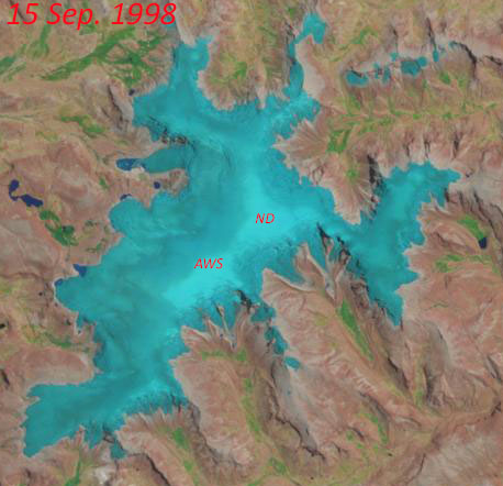
The next strong El Niño, in 1997-98, was the largest event in modern times, persisting longer and with higher anomalies than in 1982-83 (see above). Direct observations at Quelccaya are again not known, yet limited cloud cover in 1998 allowed the Thematic Mapper on Landsat 5 to provide coverage at a regular interval; an animated sequence from 18 Jan. to 2 Nov. 1998 is shown in the right-hand sidebar. Perhaps most dramatic is the 15 September scene, when 97-98 accumulation was restricted to a small area at the summit (see image below, with AWS and "North Dome" drilling site labeled). The next available image from 1998 - two weeks later - shows a thin cover of new snow, which quickly changed the surface radiation balance and effectively ended the dry season. Depending upon when this snowfall occurred within this two-week window, there was either a very thin increment of accumulation added in 1997-98 or - if ablation continued two more weeks - possibly none at all. Could this happen again in 2016?


The large-scale dynamics and timing of each El Niño vary, as does the spatial pattern of impacts. Nonetheless, we expect to see generally warmer and drier than average conditions at Quelccaya (e.g., Rabatel et al., 2013), which initial telemetry data appear to be verifying this year. At the moment our available information is restricted to accumulation and ablation, but temperature and humidity data will be back in the datastream shortly. AWS measurements show snow accumulation at the summit beginning towards the end of October, a couple weeks later than average. The latest image, acquired by Landsat 8 last Tuesday (top image), shows fresh snow on the ice cap at all but the lowest elevations (outlet glaciers). An earlier image from 30 September indicates that the transient snowline had risen considerably since our June fieldwork, when we serviced the AWS, measured accumulation, and sampled snow. SST anomalies by June were already at +1.0°, the fourth consecutive month over the +0.5° El Niño threshold. Imagery without extensive cloud cover is not available between the 30 Sep. and 17 Nov. images, but we have very intriguing AWS telemetry data!

The colorful graph below below depicts seasonal snow surface height change at Quelccaya summit. Individual hydrologic years are in different colors, with each referenced to the year's minimum height (see Fig. 3 of Hurley et al., 2015 for details). The change in surface height since June is shown as the red dotted line - with 40 percent more ablation than any other year since 2002. This ablation was most likely the result of melting, associated with above-normal air temperature, because at least two snowfall events occurred which only briefly reduced the rate of ablation. A full explanation awaits recovery of additional data.

We will continue tracking precipitation at Quelccaya during the 2015-16 wet season, and anticipate obtaining our full set of climate data and time-lapse imagery early in 2016. As the El Niño event concludes, we will visit the summit to further investigate the magnitude of accumulation, and it's impact on isotopic composition.


Thanks to Michael Rawlins and Frank Keimig (UMass Climate System Research Center) for help processing telemetry data.

[UPDATE 12/5:  The Oceanic Niño Index plot above has been updated to include the SON anomaly as well as that for just the month of November. For Niño region 3.4, this deviation of 2.35° C is the largest recorded since records began in 1950. Stay tuned!]

References
Bowen, M. (2005), Thin Ice:  Unlocking the secrets of climate in the world's highest mountains. New York:  Henry Holt & Co., ISBN 9780805064438 (also available in paperback).

Hurley, J. V., M. Vuille, D. R. Hardy, S. J. Burns, and L. G. Thompson (2015), Cold air incursions, δ18O variability, and monsoon dynamics associated with snow days at Quelccaya Ice Cap, Peru, J. Geophys. Res. Atmos., 120, doi:10.1002/2015JD023323.

Rabatel, A. and 27 others (2013), Current state of glaciers in the tropical Andes: a multi-century
perspective on glacier evolution and climate change, The Cryosphere, 7, 81-102, doi:10.5194/tc-7-81-2013

Thompson, L. G., E. Mosley-Thompson, and B. M. Arnao (1984), El-Niño Southern Oscillation Events Recorded in the Stratigraphy of the Tropical Quelccaya Ice Cap, Peru, Science, 226, 50–53.
 

Thursday, December 13, 2012

10 years for the US Climate Reference Network

Congratulations to the USCRN program on the first decade of operations!

Some of the equipment on the UMass Quelccaya weather station is compatible with that of the U.S. Climate Reference Network (USCRN), which NOAA's National Climatic Data Center (NCDC) began 10 years ago. We chose to incorporate elements of their system at our site as a result of the extensive testing and characterization they carried out. A nice overview of all USCRN aspects and prospects is contained in the Early Online Release of a paper titled "U.S. Climate Reference Network after One Decade of Operations: Status and Assessment." The paper will appear in a future issue of the Bulletin of the American Meteorological Society, and is freely available now from this link.

To stay updated on further developments of the USCRN, follow NCDC on Twitter:  @NOAANCDC