Tuesday, July 24, 2012
Un gigapan muy grande
As previous posts have indicated, Quelccaya is a large, relatively-flat ice cap. From the summit area, ice flows down and out toward the margins with much of the flow taking place via outlet glaciers such as Qori Kalis.
We shot several GigaPans at Qori Kalis this month, including the broad panorama below. Additional details about Qori Kalis and the composite panorama can be seen in a new tab by clicking on the image caption (or here for those w/o Flash). Details of the glacier are best seen in the second GigaPan below (or here). Several others will be posted shortly, illustrating details of the lake/moraines as well as areas nearby.
Tuesday, July 17, 2012
2012 Fieldwork Return
Back into Cusco last night after ~10 days at Quelccaya. With help from Vicencio Expeditions (Guide Felix, porters Theodoro and Hector, a cook and 8 horses), we accomplished just about all we hoped to. First up was locating the elusive 1983 survey points, a considerable relief. Then, 5 days and 4 nights were spent on top at the AWS, servicing the station and measuring snow. The weather was rather incredible, with cloudless days of no wind and very low humidity. Although at times we baked in the sun, quick checks suggested the air temperature remained below freezing every day; nights were invariably clear and cold. Ablation seems to have been minimal through the interval, due to the relatively fresh snow cover and dominance of sublimation over melting. More details will follow. Here are a few quickly-selected, unedited images.
1. From our tent just before sunrise on 12 July (Happy Birthday Elise).

2. Carsten prepares our morning coffee, crucial task #1 each day.

3. Here the AWS tower has been raised, and instrument adjustments/service are underway.

4. Changing out one of the temperature/humidity sensors.

5. Snowpit, part I. Eventually we went to 4.5 meters, about half again this depth. This required saws and hard effort which broke both of our steel shovels; credit for perseverance goes primarily to Theodoro and Hector (and our trusty Voilé shovel). The contact between the most recent accumulation (i.e., 2011-2012) and the 2011 dry-season surface is readily apparent.

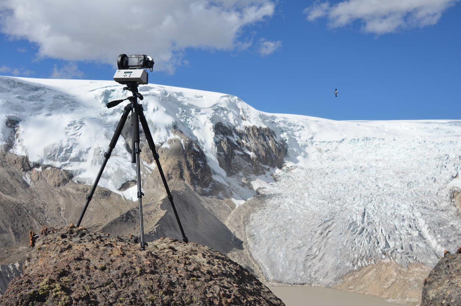
6. Qori Kalis outlet glacier, as seen while waiting for a GigaPan panorama to execute (615 images). Note the adult Mountain Caracara flying by!

1. From our tent just before sunrise on 12 July (Happy Birthday Elise).

2. Carsten prepares our morning coffee, crucial task #1 each day.

3. Here the AWS tower has been raised, and instrument adjustments/service are underway.

4. Changing out one of the temperature/humidity sensors.

5. Snowpit, part I. Eventually we went to 4.5 meters, about half again this depth. This required saws and hard effort which broke both of our steel shovels; credit for perseverance goes primarily to Theodoro and Hector (and our trusty Voilé shovel). The contact between the most recent accumulation (i.e., 2011-2012) and the 2011 dry-season surface is readily apparent.

6. Qori Kalis outlet glacier, as seen while waiting for a GigaPan panorama to execute (615 images). Note the adult Mountain Caracara flying by!
Monday, July 2, 2012
2012 Fieldwork Underway
.JPG)
This year will be a small "team" (as shown above), but we have some exciting science planned in addition to servicing the station and recovering data. First up will be locating 2 survey points on a ridge overlooking the glacier, established in 1983. Dave Chadwell installed and used these to complete a thorough 3D survey of a transect up the glacier. Re-visiting these points is an idea he came up with last year, and the National Geographic Society has decided to support the effort. So now - nearly 30 years later - we hope to find the points and establish their position with centimeter-accuracy GPS. At Scripps, Dave will then compute positions for each point in the transect, and next year we will reoccupy these points with the GPS equipment to get precise elevations. The result will establish a profile of ice thickness change over the intervening 30 years -- how cool is that?
Meanwhile, our other goal for this year is to dig a snowpit back through 2-3 years of accumulation and measure a profile of density. Equipped with detailed density profiles from previous fieldwork, we hope to learn more about ablation processes and meltwater percolation.
We arrived in Cusco today with all our gear and have begun adjusting to life at 3,400 meters. We'll continue adapting for 3 or 4 more days before moving up.
Subscribe to:
Posts (Atom)